
English subtitles now available!
Voit valita suomenkielisen tekstityksen videon valikosta.
Category: Trip Reports
Across Greenland 2018
Six women’s adventure in an ice labyrinth, avoiding crevasses, several storms, fourteen hours of skiing, a helicopter evacuation, doubt about the success of the expedition; here are some examples of what our eventful Greenland crossing included.

WHY GO?
During my exchange years in Norway I got my first experiences of winter touring. I totally fell for it! In recent years I have participated in expeditions in Sweden’s Sarek, on Iceland’s Vatnajökull glacier and on the glacier landscape of Svalbard. As the trend seems to do more challenging trips progressively, crossing Greenland by skis was naturally the next challenge for me. After all, it has for long been a big dream for me to cross Greenland by skis. Aren’t dreams made to come true?


THE ICE LABYRINTH
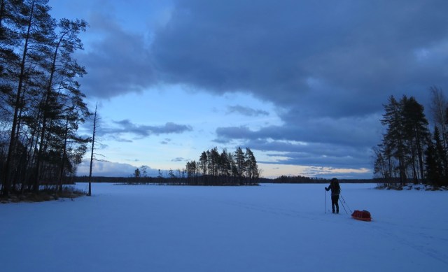
At last it was the day when we stood on the edge of the glacier near the village of Kangerlussuaq! Our eyes were facing east and it was a great feeling! One year of preparations were behind. At last we were beginning what we had been practicing for so long. The first days we navigated our way in the ice labyrinth, looking for the best route towards the icecap. With crampons on our feet we walked up and down along different ice humps with house-sized ice cliffs on our sides. Sometimes it was impossible to find a suitable direct route because of the deep crevasses. Our GPS track had formed a zigzag pattern. Because of the 80 kg behind us in our sleds, the speed was not breathtaking. At some points, we had to push one sled at a time – that can you call teamwork!


ON THE ICECAP
Eventually the ice labyrinth disappeared when the snow cover thickened. We had reached the icecap! Our next goal was to ski more than 20 km a day. Unfortunately, one of the expedition members had got severe abdominal pain, and we understood that our goal was impossible to achieve. Since her condition did not improve, we made a decision about medical evacuation by helicopter. We were prepared for a three-day delay due to storms, but these days were now used when we waited for the evacuation flight. We so hoped that a storm would not hit us at the end of the trip.


DCIM100MEDIADJI_0012.JPG
THE RADAR STATION
After the helicopter evacuation we extended our ski distances. We visited the abandoned and icy DYE2 radar station. An awesome dome building rose in the middle of the snow field. Like other expeditions, we left our name both in the guest book and on the dome wall. We wondered about the amount of goods left behind, like beer bottles and household machines! It was like the time had stopped in the 80’s. Even a Christmas ham was waiting on the table!


STORM DAYS
Then the storm hit us … 30 m/s winds forced us to spend a couple of days in tents. This meant that we needed to extend our day distances to the end of the trip, to get to the east coast in time. However, this was not the only storm we encountered, but a third full storm day was still to be spent in the tents. Our trip had now become a race against the clock! The conditions were so difficult, that we were uncertain if we would get in time to the east coast, to the plane waiting for us there. However, we had such a huge motivation to get over the glacier, so finally we skied quite absurd day distances. 14 hours and 40 km were at the end a normal day…


AT THE COAST
We looked forward to a decent downhill after the half way, but we had to wait to the last day for the real downhill … What a joy it was to ski the last meters with the land in sight!. After 30 days and 576 km we reached our goal! Thanks to the team’s great humor and will! One more night was in front on the polar bear area. We ended our ski tour on a rocky cliff where we found a small hut. We slept the last night safely inside the hut, where we waited for the morning’s helicopter lift.


Kebnekaise 2017
Scroll down for English text
Heinäkuussa matkasimme länsinaapurin maille, Pohjois-Ruotsiin. Meillä oli tavoitteena huiputtaa Ruotsin korkein vuori Kebnekaise, mutta olimme huolissamme vallitsevasta säästä. Säätiedotuksen mukaan oli luvattu paljon sadetta ja huonoa näkyvyyttä. Mietimme jopa vaihtoehtoja meidän suunnitelmiin, mutta päätimme kuitenkin käydä paikan päällä katsomassa tilannetta.
Hyppäsimme perjantai-iltana autojunaan Helsingissä ja matkasimme yön läpi kohti Oulua. Kun olimme purkaneet auton junasta, suuntasimme kohti Haaparantaa ja siitä edelleen kohti Kiirunaa. Kiirunassa hankimme viimeiset ruokatäydennykset, ja ajoimme vaelluksen alkupisteeseen Nikkaluoktaan. Kello oli jo yli viisi kun olimme vaihtaneet vaelluskamppeet päälle ja rinkat heitetty selkään. Sää oli kolealla puolella ja pilvinen, mutta poutainen. Ensimmäisen päivän urakka olisi n. 19 km ja se toisi meidät Kebnekaisen tunturiaseman lähettyville.
Ensimmäiset 6 km olivat helpohkoja ja polku muistutti lanattua mönkijätietä. Tien loppupäässä oli venekuljetuksen laituripaikka sekä uudehko ravintola. Venekuljetuksella olisi voinut säästää 6 km tallustamista, mutta 30 euron hinta ei meitä houkutellut. Tästä tie muuttui poluksi, ja paikoin aika mutaiseksi ja kivikkoiseksi. Pidimme matkan puolivälissä ruokatauon ja huomasimme samalla että hyttysiä oli jonkun verran liikkeellä… 18 km jälkeen olimme jo Kebnekaisen tunturiaseman lähettyvillä. Kello oli jo ehtinyt vierähtää seuraavalle vuorokaudelle ennen kuin olimme pystyttäneet teltat. Teltanpystytyksestä tuli kiire kun taivaalta oli ruvennut tippuamaan vettä. Vettä ropisi teltankankaalle läpi yön.
Aamulla heräsimme myöhään, mutta kuumuus pakotti meidät lopulta valveille. Keli oli aurinkoinen ja tuuleton. Aivan! Säätiedotukset eivät olleet pitäneet paikkansa! Meille tämä oli upea yllätys! Päätimme siis lähteä huiputtamaan, koska emme voineet antaa tällaisen tilaisuuden mennä sivun suun. Pääsimme matkaan klo 11. Pidimme lounastauon ennen ensimmäistä kunnollista nousua. Polku muuttui paikoin kivikentäksi, mutta reitti oli hyvin merkitty maastoon punaisilla maalitäplillä. Nousimme Vierramvaren huipulle joista näimme tulevan koitoksen nousevan vielä korkeammalle. Laskimme alas Kaffedaleniin jossa täydensimme vesipullot ennen viimeistä nousuosuutta. Kun saavuimme Kebnekaisen huipulle oli sää vielä aurinkoinen ja tuuleton. Olimme ylhäisessä yksinäisyydessä huipulla, joten meillä oli hyvin aikaa ikuistaa hetkeä kameroilla. Alastulomatkalla pidimme vielä pidemmän ruokatauon Vierramvaren huipulla, ennen kuin pääsimme takaisin leirillemme klo. 03.00.
Seuraavana päivänä nukuimme pitkään. Teltoissa oli kumminkin liian kuuma, joten raahasimme aikaisin aamulla makuualustat ulos raittiiseen ilmaan. Kun olimme loikolleet tarpeeksi, kävimme tunturiasemalla yhdellä kylmällä juomalla, ja palasimme leiriin päivällisaikohin. Päivällisen jälkeen purimme leirin ja suuntasimme kohti Nikkaluoktaa. Pystytimme teltat kun olimme kävelleet matkasta noin puolet. Aamulla jatkoimme ja saavuimme Nikkaluoktaan puolenpäivän jälkeen. Tästä alkoi kotimatka autolla kohti Etelä-Suomea.


In July, we traveled to northern Sweden. We were aiming to summit Sweden’s highest mountain Kebnekaise, but we were concerned about the prevailing weather. According to the forecast, we were going to have a lot of rain and bad visibility. We even thought about alternatives to our plans, but we decided to go ahead and go for Kebnekaise region.
Kayaking in Espoo/H:ki Archipelago
Scroll down for English text
Tällä kertaa suuntasimme Espoon ja Helsingin merille. Espoon Otsolahdessa toimii Otsolahden Melontakeskus, mistä vuokrasimme kajakit. Päiväksi oli luvattu aika tyyntä, joten päätimme suunnata ulos merelle katsastamaan eri retkisaaria. Sää ei ollutkaan niin tyyni mitä oltiin odotettu, mutta muutama aalto ei meitä haittaisi lainkaan. Otimme suunnaksi Tvijälp-saaren, mistä kartan mukaan löytyisi tuulelta ja aalloilta suojattu poukama. Kaisla oli kuitenkin valloittanut koko lahden, ja ainoa hyväksi havaittu kalliomainen maihinnousupaikka ja taukopaikka oli jo muiden retkeiljöiden käytössä.
Meloimme siis etelään, kohti Varsasaarta. Saaren etelärannalla on iso hiekkaranta, mikä varmaan houkuttelee kävijöitä helteisinä kesäpäivinä. Meitä ei kuitenkaan kiinnostanut jäädä pidemmäksi aikaa, koska eteläinen tuuli puhalsi suoraan rannalle. Jatkoimme matkaa melkein suoraan itäänpäin, kohti Käärmeluotoja. Rantauduimme Läntiselle Käärmeluodolle, jonka pohjoisrannalta löytyi hyvä hiekkaranta rantautumiseen. Lähellä rantaa sijatsi myös keittokatos, mutta tämä oli tällä hetkellä poissa käytösta palovaurion takia. Muuten saari on korkea kalliosaari, joten hyviä paikkoja maisemien ikuistamiseen löytyy monta. Pidimme ruokatauon jonka jälkeen paluumatka kohti Otsolahtea alkoi.
This time we headed to the sea in the Espoo and Helsinki area. We rented our kayaks from Otsolahti Canoe Center in Espoo. The weather forecast said the wind was going to be quite calm, so we decided to head out to the sea to look at the various islands. The wind was not so calm what we had expected, but little waves and wind would not hurt at all. We took the direction of Tvijälp Island where we, according to the map, could find a bay protected from wind and wave. However the reed had conquered the whole bay, and the only good landing and resting place was already in use.
So, we steered south to Varsasaari. The southern shore of the island has a large sandy beach, which is sure to tempt you in hot summer days. However, we were not interested in staying longer, because the southern wind blew directly into the beach. We continued our journey almost straight eastward, towards Käärmeluodot. We paddles to the Läntinen Käärmeluoto. On the north shore there was a good sandy beach to go ashore. Near the beach there was also a cooking shelter, but it was currently out of use due to a fire damage. The island is a high rocky island, so there are plenty of places to admire the landscapes. We had a lunch break, after which the return journey towards Otsolahti started.


Purtavaa Melontaretkelle
Päätimme ystävien kesken toteuttaa melontaretken. Eväiden nauttiminen olisi silloin isossa roolissa. Pakkasimme kajakkeihin polttopuita, ruokaa sekä juomista, ja suuntasimme kohti taukopaikkaamme Siuntiossa sijaitsevalle järvenrannalle. Alla olevalta videolta voit katsoa retken fiiliksiä!
We decided to take a kayak trip with my friends. The enjoyment of food was going to play a big role. We packed some firewood, food and drinks in the kayaks and headed for our camp fire place on a lakeshore in Siuntio. Watch the video above!


Leivonmäki Winter Adventure
In the early spring we did a short trip to Leivonmäki National Park in Central Finland. It’s known for swamps, shores of two lakes, forests and ridges. I would say that Leivonmäki is a very versatile National Park. Here you can go hiking and kayaking in the summer, and in the winter you also can go cross-country skiing. I you choose to go kayaking or skiing it gives you the opportunity to visit the camp sites on the islands. Here’s a map for the area: Leivonmäki (luontoon.fi).


We arrived in Leivonmäki late in the evening when it was dark. Our base camp was a small hut, at Harjunlahti, without electricity. Our first plan was to just ski away to a camp site, but the hut looked so cozy, that we decided to stay indoors for the night. The problem was that we had planned to eat some sandwiches, grilled over open fire, wrapped in aluminium foil. But now we were inside, with a heating stove, so no open fire. Well, we found out that we had a disposable grill with us, so we just turned it into an oven! We placed the oven on the stove’s top. The oven sandwiches were super! We also made some product development, and for breakfast, when we also ate warm sandwiches, the oven was equipped with an additional bottom, so the sandwiches wouldn’t get burned.


In the morning we skied to the actual National Park, to the lake Rutajärvi, Keskisenvesi. We were really surprised how empty the park was, and we saw only a few others on the ice. We skied eastbound towards the other lake, Kirkkoselkä, but we had to ski through a narrow strait to get to the lake.


As we imagined the strait was an open water channel, so we skied on the shore of the strait. It was a little bit challenging with the pulk, especially in the forest, but we managed to get through to the other side.


We found the camp site and shelter Halttunen on an island, where we prepared some food. We had a really long lunch break. It was still early in the day, so we decided to ski to another camp site to put up tents for the night.


We skied back in our own ski tracks, and when we reached Joutsniemi ridge, we took a short cut over it, so we got to the to camp sites on the west side: Joutsniemi and Lintuniemi camp sites. At Lintuniemi you can also find a shelter.


I the evening we decided for some night skiing, and we had got a little bit lazy. We skied back to our base camp at Harjunlahti for the night. Next morning we had got some new snow! The winter was back!
An island on an island
In Espoo archipelago there’s an island on the sea called Pentala. On this island, there’s a lake. On the lake there’s an island. That was our destination!

There are couple of reasons why we wanted to visit this island. The first introduction we got of this place was from a board game that we played many years ago with my friends. The board game was published in 1992 by the kayaking club Canoa for their 60th anniversary. In the game you are kayaking around and collecting bird observations. The rarer the birds are, the more points they are worth. There is also a dodo in the game, and since it is extinct since 1700 it’s worth the most!
")
")
")
")
")
In the game you can carry your kayak on land, for example if you want to visit the island on Pentala. So, it was from this game we got the idea to do this same thing in real life! We were also assured that we were going to find the extinct dodo on this island! We also knew that there was a geocache on this island, so we definitely had to log that as well!
On a sunny day we jumped in our kayaks and started paddling towards Pentala. We started our tour near Hirsala, so it didn’t take a long time to reach our destination. We stranded on a beach in the south of the island Pentala. From there we took a path towards the lake carrying on one kayak. We chose the wrong path, because we ended up climbing over the highest point before we reached the lake. The distance was about 400 m. But it was really worth it!

A coffee break on the beach before our adventure

Let’s go! Towards the lake!

Uphill and downhill

A little bit of jungle…

A shorter kayak would have been easier to carry in the woods.
The lake was surrounded by green leafy plants, the water was completely still, except for a few waves a pair of swans caused. And there on the lake, we saw our destination: the island! In turns, we jumped in the kayak and paddled around the island. We also stranded on the island and logged the geocache, as it was one of our goals.


Yey! I’m kayaking around an island on a lake on an island on the sea!
On the way back we found the right path, and it was so much easier to carry the kayak that way! Sadly, we didn’t spot any dodo birds, but now we can check one item from our bucket lists 😉

Svalbard Trip Report
You can now read about our expedition on Svalbard by clicking the link:

The trip was organized by Ankarat Avotunturit. If you are interested in arctic expeditions I recommend you to check out their courses, programs and expeditons: Ankarat Avotunturit.
