Greenland plans for 2018

Greenland map

Scroll down for English text

Grönlantisuunnitelmia

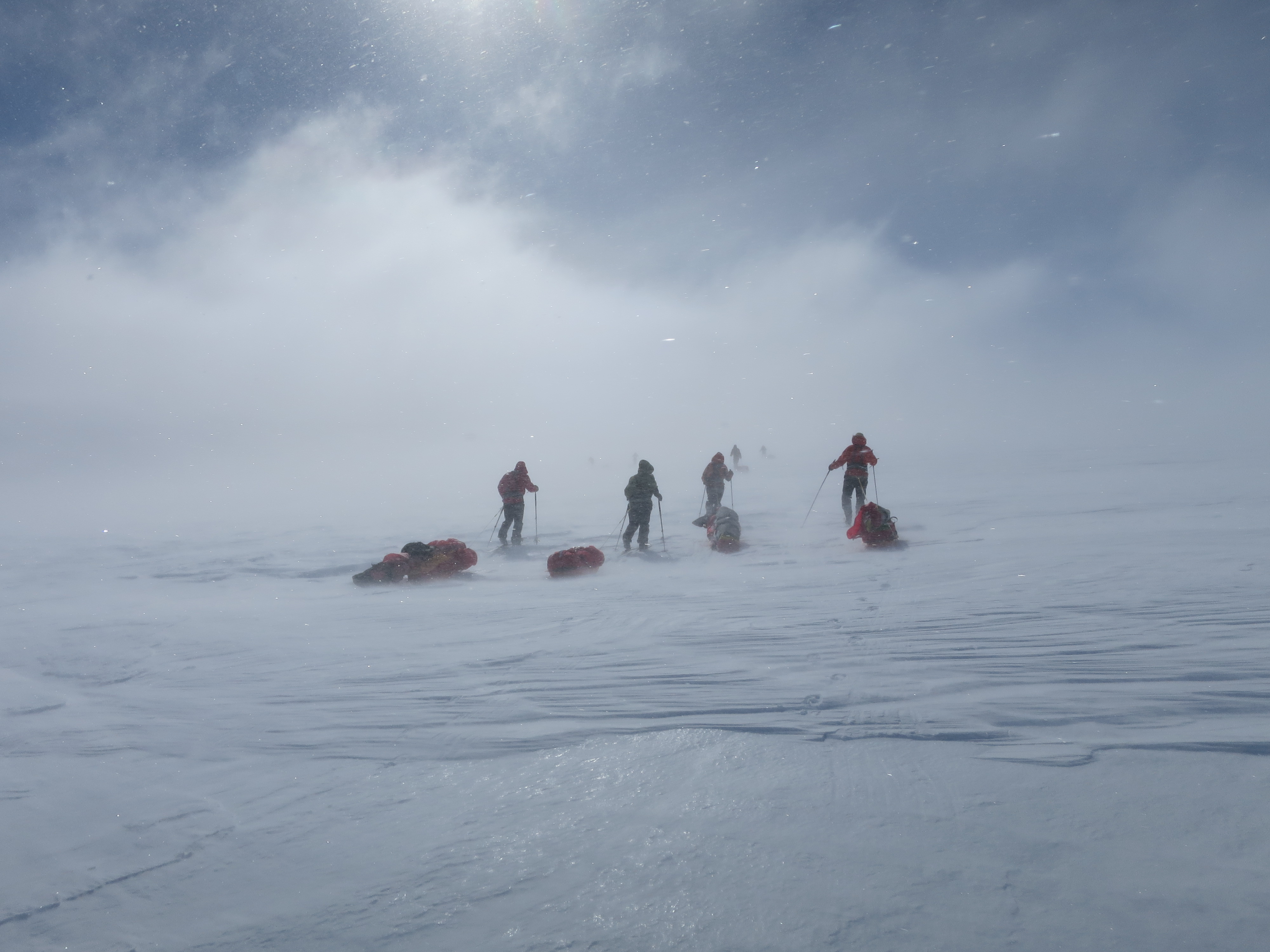
Jippii! Viimeinkin vuosi on vaihtunut ja tänä vuonna on sitten isompi seikkailu edessä: Olen lähdössä Grönlantiin huhtikuussa 2018! Tavoitteena on hiihtää Grönlannin yli lännestä itään. Reissu on Ankarat Avotunturit -organisaation järjestämä ja meidän retkikuntaan kuuluu kuusi suomalaista naista. Naisvoimalla siis mennään! Suunnitelmat ovat jo pitkällä ja helmikuussa lähdemme retkikunnan kanssa harjoitusretkelle johonkin (toivottavasti kylmään) paikkaan Suomeen.

Reitti ja olosuhteet

Lähdemme hiihtämään Grönlannin länsirannikolta Kangerlussuaq-kylän lähettyviltä sijaitsevalta Point 660 -paikasta ja päämäärämme on Isortoq- tai Tasilaaq-kylä itärannikolla. Matkaa kertyy n. 570 km ja siihen kuluu n. 30 päivää. Ensimmäiset 300 kilometrit ovat loivaa nousua ja korkeimman kohdan (2500 mpy) jälkeen edessä on taas loivaa laskua.  Olemme varautuneet 0°C – -35°C lämpötiloihin ja olemme myös ottaneet huomioon myrskyt, railot ja jääkarhuvaaran. Retkikunta on tukematon, joten kaikki tarvittavat tavarat (ruoat, keitinpolttoaineet, vaatteet ja varusteet) vedämme perässämme ahkioissa.

Yhteistyökumppanit

Tärkeät yhteistyökumppanit ovat mahdollistaneet osallistumiseni näin mahtavaan projektiin. Niiden kanssa on hienoa jakaa elämykset! Kiitos Eskimo ja Santa Maria, tästä tulee aivan huikea seikkailu!


Greenland plans

Yippee! This year there is a bigger adventure ahead: I’m going to Greenland in April 2018! The plan is to ski across Greenland from west to east. The trip is organized by the Ankarat Avotunturit organization and our expedition includes six women from Finland. In February we going on a short a training trip to, hopefully, a cold place in Finland. 

Route and conditions

We are going to ski from the west coast of Greenland, Point 660, located near the village of Kangerlussuaq, and our aim is the Isortoq or Tasilaaq village on the east coast. The distance is approximately 570 km and it will take us about 30 days. The first 300 kilometers we are going gentle uphill and after the highest point (2500 mpy) there is again bearly noticable downhill. We have prepared for temperatures from 0°C to -35°C and we have also taken into account risks as storms, crevasses and polar bears. The expedition is unsupported, so all the necessary goods (food, cooking fuel, clothing and equipment) we will pull behind us in pulks.

Partners

Important partners have made it possible for me to participate in this great project. With them, it’s great to share experiences! Thanks to Eskimo and Santa Maria, this will be a great adventure!

Soon it’s off to Svalbard!

The final preparations for the Svalbard expedition are in full swing! We are flying early in the morning, but everything is finally packed ready. It looks as if my final weight of the sled will be below 70 kg, which is nice! The last thing I have done is to update the playlist on my iPod, but I realized that I had not so much music on my computer, so it will be for me to listen again and again the same songs

I’m glad I’ve packed my warmest sleeping bag combination, because the forecast is on the cold mode in the beginning of the week… Luckily the weather gets warmer by the end of the week.

Screen Shot 2016-03-21 at 22.56.19
Screen shot from yr.no

Svalbard Training Weekend

Screen Shot 2016-02-01 at 17.16.09
The route: Laivaranta – Kelvenne – Laivaranta

This weekend we had a meeting for our Svalbard expedition. The program included skiing and an overnight stay in tents at Päijänne in Padasjoki. I had an important family event on Saturday, so I took myself to the meeting late in the evening. It was a thoroughly “find the rest of the expedition on the lake of Päijänne” -mission for me. After a two hour drive up to Padasjoki I packed my sled at the Laivaranta harbour. I noticed it already had gone well past eight in the evening, so I had to make my way with the help of my headlamp. I took the course towards the elongated island Kelvenne, which was about 8 km from the harbour.

The weather could have been more Svalbard-like with lots of snow and temperatures well below zero … Instead I skied through slush and water up to my ankles, varying to hard ice surface were you only could go forward with double poling technique (finnish: tasatyöntö). After a two-hour ice skiing I found the camp! They had set up the tents on, what I believe, was the only snow patch of the entire Päijänne. My tent mates had our tent heated, so it was just for me to take off my skis and start to enjoy the evening. The idea of ​​the whole exercise was that we would be able test the equipment we will be using in Svalbard, the most important perhaps the tent, and to meet our tent mates. We’ll stay three persons in a Helsport Svea 4 tent, and it seemed perfectly fine in terms of space. The rest of the expedtion members will share tents in pairs.

During the night, the big snow patch which was the base of our camp, had melted more, and there was now a proper swimming pool in our tent’s vestibule. In the morning it was getting colder, so after we took down our camp we skied off on a hard and icy surface. We tried, where possible, to take us to the shores where there was little snow, but the joy was not as long as we would cross a larger ice area and more slippery and hard ice surfaces. So double poling was the big thing again… We skied a litter longer route back to the harbour, and had a short after ski meeting at the nearby service station. The whole exercise was good training for the Svalbard expedition, and it was great to meet some of the other expedition members, and especially my tent mates! I think we are going to have an awesome expedition in March!

Svalbard in March 2016!

You can truly call this an extempore trip! I had no plans to travel abroad during the spring. Instead I was planning to spend the spring quietly at home with a few ski trips. For about a week ago those plans changed completely: I’m going to Svalbard for a ski expedition in the end of March for three weeks! Svalbard is a group of islands located about midway between continental Norway and the North Pole, and yes – there are polar bears walking around.

During these three weeks our plan is to ski about 300 km. We will start the expedition from the town Longyearbyen. If the weather is on our side the plan is to summit the highest mountain peaks Newtontoppen (1713 m) and Perriertoppen (1712 m). We will also visit Pyramiden, which is an abandoned Soviet mining town.

On a typical day we are going to ski about 7-8 hours and the night we are spending in our tents. The sledges will weight about 70-80 kg, but the sledges will get more lighter when the trip progresses.

The expedition is organized by Ankarat Avotunturit, the same company that organized the Vatnajökull expedition last year.

I will write about the training and planning for the Svalbard expedition during the spring, so stay tuned!

1008px-Topographic_map_of_Svalbard.svg
Topographic Map of Svalbard – By Oona Räisänen (Mysid) [GFDL or CC BY-SA 4.0-3.0-2.5-2.0-1.0], via Wikimedia Commons

Crossing Vatnajökull

You can read about the Vatnajökull expedition we did in May 2105, by clicking the link below:

VATNAJÖKULL 2015

The trip was organized by Ankarat Avotunturit. If you are interested in arctic expeditions I recommend you to check out their courses, programs and expeditons:  Ankarat Avotunturit. If you want to read the blog we wrote from day to day on the glacier you’ll find it here:  Blogi Vatnajökull (in Finnish).

IMG_0360
The expedition across Vatnajökull.